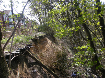
The Cliff landslip - note the precarious position of the houses (Photo: Marjorie Mosley)
|
On a beautiful sunny afternoon, a group of ten assembled in Lower Broughton Road. Salford. Most of us had arrived on foot or by
the excellent GM public transport system. Tony explained that we were on the northern edge of the Cheshire Basin, on rocks of the
Permo-Triassic (295-200 ma) that are cut by north-west trending faults of the Carboniferous Coal Measures, and dip at a slight angle
to the south and south west. During the Quaternary they were covered with a thick and extensive 'blanket' of glacial and glaciofluvial
deposits that provide an economic resource in the region.
Walking a short distance up Lower Broughton Road Tony pointed out a row of Arts and Crafts Movement houses built in 1906 for teachers at Manchester Grammar School, and further on the training ground of Manchester United Football Club. On the right, in Priory Grove, is the site of the home of William Crabtree (1610-1644), a mathematician and close observer of the planets, especially Venus, Jupiter, and Saturn. His aim was to refine Kepler's predictions of planetary motion after the lost chance to view the transit of Venus in 1619. Crabtree corresponded with Jeremiah Horrocks (1619-1641) a mathematician and amateur astronomer of Toxteth, and using the Rudolphine Tables the transit of Venus was predicted for 24 November 1639. With Horrocks in Bretherton, near Preston, and Crabtree in Broughton, the successful transit of Venus across the setting sun was recorded by them both. The transit of Venus is a rare event, having most recently occurred on 6 June 2010. The next occasion will be in 2117. |
|
The Cliff landslip - note the precarious position of the houses (Photo: Marjorie Mosley) |
At the top of the hill is The Cliff, composed of glacial sand and gravel on top of boulder clay, part of a ridge of glaciofluvial outwash sands extending from Swinton through to Pendlebury and across the Irwell valley to Prestwich and Cheetham Hill. At The Cliff the River Irwell, meandering against the ridge between Lower Kersal and Higher Broughton, has undercut a steep slope in these sands and gravels resulting in an unstable area of landslips and erosion. Evidence of this can be seen from the precarious position of the remaining tramlines, some sections of which, along with the road and pavement have slipped downwards towards the river. This instability resulted in the tramway being diverted in 1927. More landslips are to be expected, especially after heavy rain, as water moving down through the sand to the impervious clay, causes slip and movement sideways. Interestingly, the edge of the remaining pavement still has its metal studded safety kerb to protect the stone from wear and tear by horses' hooves. |
|
Descending The Cliff into the River Irwell, we saw gravel spits and undercutting of the banks - the result of rapid erosion by the river. Displaced duckboards, arising from the slippage of the boulder clay, are another indication of The Cliff's instability. Because of improved water quality, the river is allegedly home to otters, mink, and fish eating ducks. To one side of the path, at the point of the sand-clay contact is an ochre stained boggy area. Using a pH meter Tony demonstrated that the ochre mud has pH 5.9. He explained that this is caused by the oxidation of pyrite in the sediment to form sulphuric acid and ferric oxide, which then reacts to form the ochre - ferric hydroxide. The pyrite may have been carried to the site in glacial till and oxidised locally, or the ochre may have formed in drainage water from nearby coalmines. (Thank you to Fred Owen for his input here) |
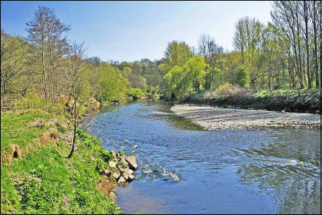 River Irwell and an imbricated pebble bank (Photo: Fred Owen) |
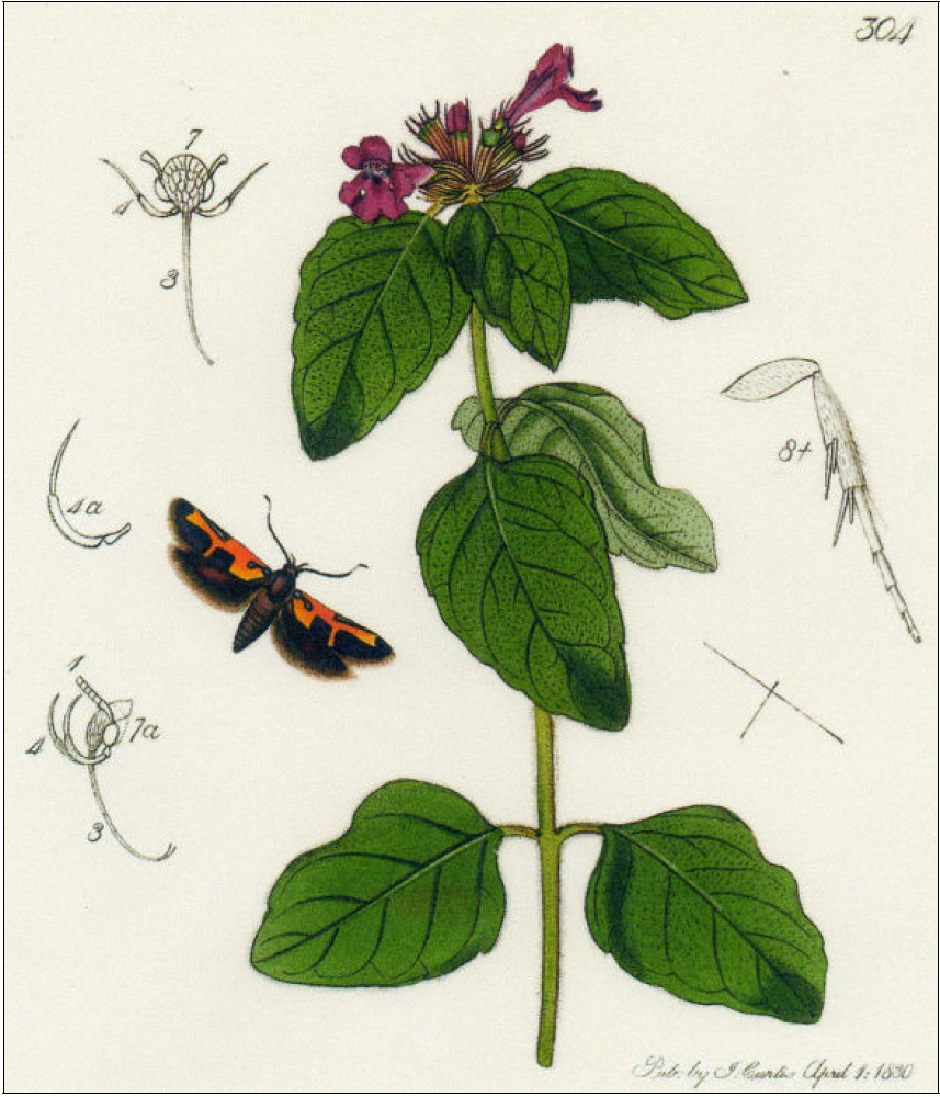 Euclemensia woodiella |
In St. Paul's Cemetery, Broughton is the granite headstone of Alexander T. Cussons (14.7.1875 - 20.8.1951) the soap magnate, known best for his Imperial Leather soap. He established the very first Cussons' soap factory in Kersal Vale, only recently demolished. The Cemetery is also the resting place of Robert A. Smith (15.2.1817 - 12.5.1884) famous for his research on air pollution carried out in 1852 in Manchester, in the course of which he discovered and coined the term acid rain.
Adjacent to the cemetery is Kersal Moor, a Site of Biological Importance, with heather and deciduous trees, mostly oaks, growing on Quarternary fluvial-glacial sediments of gravels. Looking north west towards Swinton and Pendlebury Tony pointed out the aforementioned ridge of glaciofluvial outwash sands extending across the valley to Prestwich and Cheetham Hill. In the past The Moor was used for military manoeuvres and public meetings - famously the Great Chartist Meeting of 1838, which prompted Friedrich Engels to dub it "the Mons Sacre of Manchester". The Moor was once the habitat of the now extinct Manchester Moth, Euclemensia woodiella. Only three specimens of this moth have survived and they can be seen in the Natural History Museum, London, Museum Victoria, Australia, and the Manchester Museum. The specimen in Manchester Museum is too fragile for general display, and can only be viewed by arrangement. Leaving the Moor by a footpath through a golf course, and crossing Hilton Lane, we entered Drinkwater Park. Across a stream on the right, is an outcrop of early Triassic rock of the Sherwood Sandstone Group, topped by glacial drift. The rock is bright red with well-sorted rounded frosted grains, and contains a layer of mudclasts about 3cms deep, intermittently visible laterally along the outcrop. This indicates a continental aeolian desert environment with flash floods. The outcrop is saturated and is extremely friable. Nearby, at Agecroft Bridge, is the decorative ironwork aqueduct transporting Thirlmere water up to Heaton Park. On both banks of the River Irwell can be seen inaccessible outcrops of dull red Triassic sandstone recorded as "containing a few quartz pebbles". (L. Livingstone, 17/11/1978). |
|
Walking along the banks of the Irwell, west of Littleton Road, Kersal, we saw the River Irwell Flood Defence Scheme. After many devastating floods of the lower reaches of the River Irwell, the latest in 1980, the River Irwell Flood Defence Scheme was officially opened in 2005, and the levees and playing fields alongside the river act as an emergency water catchment area. Just off Littleton Road is Kersal Cell, the site of a Cluniac Monastery, established sometime between the twelfth and fourteenth centuries. The Cluniacs were a branch of the Benedictine order originally established in the tenth Century in the Burgundian region of France; the present building was built in 1563. Returning to the river bank we saw, on the opposite bank, landslips and deposits from the 2008 flood, and through binoculars, pebbles showing an imbricate structure. Further along the river, on the opposite bank again, was an inaccessible outcrop of Permo-Triassic sandstone. Walking across the vast green area that was once Manchester Racecourse, sold for Ł45,000 in the 1960's to Salford University, we made our way to Cromwell Bridge and the end of our walk. We thanked Tony for a very enjoyable and engaging afternoon and proving to us that Salford is not just notable for L. S. Lowry. Marjorie Mosley |
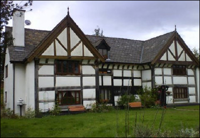 Kersal Cell built 1563 |