Anglezarke and Rivington Field Trip - Sunday 23rd July 2006
On a sunny Sunday July morning 12 members of the MGA, OUGS and Westmorland GA met leader, Alan Diggles of the OUGS, at White Coppice cricket pitch, Anglezarke. Our aim was to explore the influence of geology and geomorphology on the area, with particular reference to the economic resources of lead ore deposits, coal, building stone and water.
Anglezarke lies at the western edge of the Rossendale Anticline and consists mainly of Carboniferous rocks of the Millstone Grit group. These sandstones were deposited towards the end of the Namurian period when the filling of the Craven Basin, by southerly flowing rivers, was almost complete. Later, rocks of the Westphalian (Coal Measures) were deposited. The rocks are virtually horizontal, with a dip generally, of no more that 10 degrees and consist of fairly massive, coarse to medium grained, cross stratified sandstones. The sandstones are separated by shales, mudstones and siltstones which are little exposed, except at stream sections and usually, just above the sandstone, can be found fossiliferous marine bands containing goniatites and bivalves.
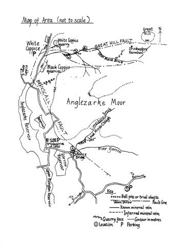
Using an ingenious teaching aid of sliding cards Alan described the fault lines influencing the geology. The north trending Brinscall fault separates the rocks on Anglezarke Moor from the heavily faulted area to the west. This results in exposure of Helmshore and Fletcher Bank Grits on the high moorlands to the east and on the western downthrow side of the fault, the younger, softer rocks of Upper Haslingden Flags and Rough Rock. The east trending Great Hill Fault lying at approximately 90 degrees to the Brinscall fault can be seen in White Coppice Quarry. The area was mineralised after faulting, resulting in veins yielding mainly galena, barite and witherite.
Glacial deposits cover much of the area in the form of a blanket of till and contain glacial erratics from the Lake District and Southern Uplands thus indicating that the source of the ice was from the North West. Meltwater channels were formed during glaciation and the deep gorge between Brinscall, White Coppice and Anglezarke Reservoir has been exploited for water collection. Large parts of the moors are overlain by post glacial peat within which, around the northern shoulder of Anglezarke Moor, Mesolithic flint and chert artefacts can be found.
Alan led us over the Goit feeder channel linking Anglezarke reservoir to three smaller ones further to the north east. Looking east, and standing on the downthrown side of the Brinscall Fault, at this point ~ 230m., could be seen the prominent 50m high escarpment of hard Fletcher Bank Grit of the disused Black Coppice Quarry. Alan assured us that at the top of the escarpment were two millstones. As the day was rather warm no one offered to climb the quarry to take a look.
Retracing our steps for a short distance we crossed Dean Black Brook, passing a sluice gate on the right and ascended to location 1, the disused White Coppice Quarry of Fletcher Bank Grit. Here can be seen the easterly trending Great Hill fault with its 2.7m wide vein of highly weathered mineralized fault breccia containing calcite, barite and witherite. At the base of the quarry is a bricked up adit that had yielded no lead. The coarse Fletcher Bank sandstones show fining up and contain sub-rounded thumb-nail sized quartz pebbles. On the quarry face are slickensides and high up on the under side of an overhang, fossilised tree bark.
At location 2, on the south side of Dean Brook, there is a small easterly trending fault with two spoil heaps containing traces of barites, calcite and galena with remnant bell pits tracing the line of the fault. Here the brook turns at two places through 120 degrees and back again, exploiting the joints and faults in the rock.
At location 3, on the south side of the brook is a partially bricked up adit to the left of which is a fine example of slickensides and deposits of limonite deposited by mine drainage. To the right of the adit a fault is marked by a shallow inclined trough with differentially eroded breccia.
Further upstream at location 4, as the valley widens, is a bluff with exposures of Fletcher Bank and overlying Helmshore Grits between which can be found shales and siltstones with ironstone bands. Above this there is about 5m of glacial till containing erratics. Some members of the group found examples of limestone, granite and basalt in the stream bed.
We returned to White Coppice by the higher footpath giving views as far as the Ribble Estuary and, Alan assured us, on clear days, the Lake District.
After a pleasant lunch around White Coppice cricket pitch we made our way to a viewing point (SD 62042 16370). An excellent view may be had of the deep and extensive system of melt-water channels between Chorley and Bolton, the deepest of which is now mainly occupied by a number of reservoirs. Looking south westwards into the middle distance can be seen the Harrock Hill-Ashurst Beacon-Billinge ridge formed by hard sandstones within the Lower Coal Measures and looking westwards, we could see the Lancashire plain and Blackpool Tower.
Going by the disused Anglesarke quarry of Fletcher Bank Grits we took the Belmont road passing from sandstone into Westphalian clay and shales to location 5. Parking by the road side (SD 64352 15395) we clambered down a steep slope into a narrow stream valley to the site of a slight fault with sandstone on one side and shales on the other. On the hillside is a small coal seam recently exposed by a landslide.
Retracing our steps up to the road we made our way to location 6 , Lead Mines Clough, parking at Alance Bridge (SD 62782 15960). The earliest record of mining in Lead Mines Clough dates back to 1692. After years of stop/start ventures the mines reached their peak of production in 1781-1790 and in 1788-1789, 73 tons of lead were produced. During this period the locality became famous for the discovery of witherite which was used secretly by Josiah Wedgwood at his works in Eturia for the production of Jasper ware. Even in recent years witherite, because it contains arsenic, was used locally as a rat poison. The mine ceased working in 1837.
Passing through a gate, with Yarrow Reservoir on our right, we made our way down Lead Mines Clough. The effects of the Brinscall fault can be seen here in a small waterfall. On the upstream side of the waterfall the Fletcher Bank Grit crops out and the stream falls over the slickensided fault surface. Immediately downstream on the downthrow side the shales show the “drag” effects of the faulting. At stream level, in the shales, can be found a fossiliferous marine band containing goniatites and bivalves.
With spoil heaps from the lead mines on our right, we crossed the footbridge to the site of the restored waterwheel pit and the top of a pumping shaft, all that remains of mine’s drainage system. Overshot from above with water from a launder, the 5.5m diameter water wheel was connected on the far side by a crank to pump rods in the pumping shaft situated just in front of the wheel pit. It is thought that on the other side of the waterwheel there was a set of rollers used to crush lead ore. As time was running out, this site, unfortunately, was the last one. No time, alas, to root around the spoil heaps for bits of galena, pyrite or barite and most prized of all, witherite.
On returning to Alance Bridge we thanked Alan for an interesting and enjoyable day and Jane for providing the sunshine.
Marjorie Mosley
References
Grayson, Robin R & Williamson, Iain A Geological Routes around Wigan. Wigan and District Geological Society, 1977.
Williamson, Iain A The Anglezarke Lead Mines. Min.Mag. 108, 133-139, May, 1963.
**************************************